Divided into intrusive and extrusive features or land forms.
1.Intrusive/Plutonic Features
-Features formed by intrusive Vulcanicity when materials intrude the earth’s crust.
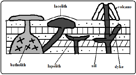
2.Sill
-An igneous intrusion which lies along a bending plane of rock strata.
-Formed when magma forces its way between rock layers then cools and solidifies.
-It forms ridge like escarpments when exposed by erosion e.g. Fouta Djalon highland of Guinea and 3 sisters of S. Africa.
3.Dyke
-A wall-like igneous intrusion which lies across the bedding plane of rock strata.
-Formed when magma intrudes cracks or faults cutting across bedding planes of rocks then cools and solidifies.
-Can be vertical or inclined.
When exposed it forms ridges e.g. Kaap Valley in Transvaal S. Africa and Jos Plateau in Nigeria.
4.Laccolith
-A mushroom-shaped igneous intrusion lying between bending planes of a country rock.
-Formed when viscous magma pushes its way through a vent and accumulates around the vent before reaching the earth’s surface pushing the overlying rock into a dome shape.
-It’s so high that land is turned into mountains e.g. El Koub Hill in Algeria, Henry Mountains in Utah U.S.A and Fonjay Massif in Madagascar.
5. Batholiths
-Largest igneous intrusion formed underground formed when very hot magma intrudes bedding planes of rocks and replaces or metamorphoses it e.g. Chaila Massif in Gabon, Ikhonga-Murwe in Kakamega and the largest is in British Columbia.
6. Lopolith
-a large saucer shaped igneous intrusion formed when viscous magma intrudes into bedding planes of a country rock. They form shallow depressions on the earth’s surface of the earth e.g. Bushveld complex in S. Africa and Duluth Gabbro mass in U.S.A.
7. Phacolith
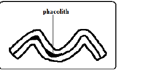
-A lens shaped igneous intrusion which forms in the crest or trough of an anticline e.g. Corndon Hill in England.
marto answered the question on
March 25, 2019 at 06:05