-The region receives rainfall throughout the year
- Total annual rainfall ranges from 1000mm to 1500mm
- The region has double maximum rainfall in the east/single maximum in the west
- The long rains are received between March and May and the short rains between September and December in the east/the peak is between May and August in the west
- Rainfall is higher on the windward slopes than on the leeward slopes of the highlands
- Rainfall is caused mainly by SE trade winds
- The area receives mainly relief rainfall/orographic
- The average temperature ranges between 17oC and 24oC/warm temperatures
- The lower slopes are warmer that the higher slopes/temperatures are modified by altitude
- The area experiences moderate humidity
- The coolest months are between June and August while the rest of the year remains warm
- Day temperatures are warm while nights are cool/chilly
- Mean annual range of temperature is small (3 – 5oC)
sharon kalunda answered the question on April 17, 2019 at 07:19
-
The diagram below represents the internal structure of the earth. Use it to answer question
(Solved)
The diagram below represents the internal structure of the earth. Use it to answer the question that follow.
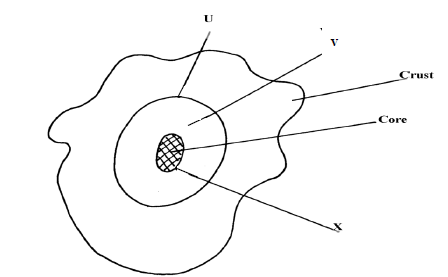
Name the parts named u, v and x.
Date posted:
April 17, 2019
.
Answers (1)
-
Name two equinoxal dates
(Solved)
Name two equinoxal dates
Date posted:
April 17, 2019
.
Answers (1)
-
What is an equinoxal date?
(Solved)
What is an equinoxal date?
Date posted:
April 17, 2019
.
Answers (1)
-
Give two effects of the elliptical shape of the earth
(Solved)
Give two effects of the elliptical shape of the earth
Date posted:
April 17, 2019
.
Answers (1)
-
The diagram below represents an eclipse. Use it to answer the following questions:
(Solved)
The diagram below represents an eclipse. Use it to answer the following questions:
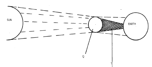
(i) Name the type of eclipse
(ii) Identify the parts marked Q and T
Date posted:
April 17, 2019
.
Answers (1)
-
State any two characteristics of Latitudes.
(Solved)
State any two characteristics of Latitudes.
Date posted:
April 17, 2019
.
Answers (1)
-
Give the reason why the International Date Line is significant.
(Solved)
Give the reason why the International Date Line is significant.
Date posted:
April 17, 2019
.
Answers (1)
-
Name two planets without natural satellites in the solar system
(Solved)
Name two planets without natural satellites in the solar system
Date posted:
April 17, 2019
.
Answers (1)
-
Name two local winds experienced around lake Victoria region.
(Solved)
Name two local winds experienced around lake Victoria region.
Date posted:
April 17, 2019
.
Answers (1)
-
When the local time is 2.00 p.m at longitude 45°E, what is the longitude of a place whose local time is 10.30 a.m
(Solved)
When the local time is 2.00 p.m at longitude 45°E, what is the longitude of a place whose local time is 10.30 a.m
Date posted:
April 17, 2019
.
Answers (1)
-
The diagram below represents the earth on its axis. Use it to answer question
(Solved)
The diagram below represents the earth on its axis. Use it to answer questions that follow

i) Name the latitude marked G
ii) What is the angle of inclination of the earth’s axis from its orbit
Date posted:
April 17, 2019
.
Answers (1)
-
Explain why the study of Geography is beneficial in the management and conservation of the environment.
(Solved)
Explain why the study of Geography is beneficial in the management and conservation of the environment.
Date posted:
April 17, 2019
.
Answers (1)
-
Differentiate between a mofette and a fumarole
(Solved)
Differentiate between a mofette and a fumarole.
Date posted:
April 8, 2019
.
Answers (1)
-
Explain the influence of altitude on vegetation distribution
(Solved)
Influence of altitude on vegetation distribution.
Date posted:
April 3, 2019
.
Answers (1)
-
In which major climatic regions of the world are the following types of vegetation found.
a. Selvas
b. The maquis or chapparal
c. The pampas
d. Taiga
(Solved)
In which major climatic regions of the world are the following types of vegetation found.
a. Selvas
b. The maquis or chapparal
c. The pampas
d. Taiga
Date posted:
April 3, 2019
.
Answers (1)
-
Distinguish between block disintegration and granular disintegration
(Solved)
Distinguish between block disintegration and granular disintegration
Date posted:
April 3, 2019
.
Answers (1)
-
Outline ways in which mountains influence climate in Kenya
(Solved)
Outline ways in which mountains influence climate in Kenya.
Date posted:
April 2, 2019
.
Answers (1)
-
Explain three factors that hinder the development of solar energy.
(Solved)
Explain three factors that hinder the development of solar energy.
Date posted:
April 1, 2019
.
Answers (1)
-
Name two major lake ports in Kenya along lake Victoria other than Kisumu
(Solved)
Name two major lake ports in Kenya along lake Victoria other than Kisumu
Date posted:
April 1, 2019
.
Answers (1)
-
Suppose you were to carry out a field study of rocks within the school environment.
(i) Name two secondary sources of data you would use to...
(Solved)
Suppose you were to carry out a field study of rocks within the school environment.
(i) Name two secondary sources of data you would use to prepare for the field study.
(ii) State three problems you are likely to face during the field study.
Date posted:
April 1, 2019
.
Answers (1)