(i) Lithosphere/crust
- It is made up of two layers /sial and sima
- Sial is the upper layer and consist of silicon and Aluminium
- It extends between 6-80km
- Sima consists of silicon and Magnesium
- Sial mainly consist of granific rocks
- Sial has a density of between 2.65 to 2.70gm/cc
- Sial mainly consist of basaltic rocks
- Sima has density of between 2.7 to 3.0 gm/cc
- Sima is some how flexible
(b) Core
- It is divided into inner and outer core
- Outer core is mainly made of iron and nickel
- Inner core is mad up of iron
- Density of the core ranges from 12gm/cc to 17g/cc
- It has a radius of about 3450km
- The inner core is in solid state
Kavungya answered the question on May 29, 2019 at 06:54
- What is physical environment?(Solved)
What is physical environment?
Date posted: May 29, 2019. Answers (1)
- A from four class carried out a field study on industrialization in Thika town.
(i) Give two possible objectives of their study.
(ii) List two methods...(Solved)
A from four class carried out a field study on industrialization in Thika town.
(i) Give two possible objectives of their study.
(ii) List two methods of data recording that they will use to record the data.
Date posted: May 29, 2019. Answers (1)
- Describe the measures which should be taken by the Kenyan government to control effects of industrialization.(Solved)
Describe the measures which should be taken by the Kenyan government to control effects of industrialization.
Date posted: May 29, 2019. Answers (1)
- Give four reasons why Kenya should become an industrialized country as per the vision 2030.(Solved)
Give four reasons why Kenya should become an industrialized country as per the vision 2030.
Date posted: May 29, 2019. Answers (1)
- Identify the main industries found in each of the following towns.
- Kisumu
- Nakuru(Solved)
Identify the main industries found in each of the following towns.
- Kisumu
- Nakuru
Date posted: May 29, 2019. Answers (1)
- Explain how the following factors hinder transport and communication in Africa.
- Terrain.
- Shortage of skilled labour.(Solved)
Explain how the following factors hinder transport and communication in Africa.
- Terrain.
- Shortage of skilled labour.
Date posted: May 29, 2019. Answers (1)
- Draw a sketch map of the Great Lakes and St. Lawrence Seaway. On it mark and name the following:-
- Lakes Michigan and Ontario.
- Ports...(Solved)
Draw a sketch map of the Great Lakes and St. Lawrence Seaway. On it mark and name the following:-
- Lakes Michigan and Ontario.
- Ports Duluth and Chicago.
Date posted: May 29, 2019. Answers (1)
- Outline three benefits derived from the construction of Nairobi-Thika super highway.(Solved)
Outline three benefits derived from the construction of Nairobi-Thika super highway.
Date posted: May 29, 2019. Answers (1)
- Draw an outline map of Kenya.
On it mark and name the following:-
- Marsabit game reserve.
- Dodori game reserve.
- Aberdare National park.(Solved)
Draw an outline map of Kenya.
On it mark and name the following:-
- Marsabit game reserve.
- Dodori game reserve.
- Aberdare National park.
Date posted: May 29, 2019. Answers (1)
- The table below shows countries X, Y and Z sugarcane production in 1000 tonnes from 1976-1980.
(i) Draw comparative bar graph to represent the data.
(ii) State...(Solved)
The table below shows countries X, Y and Z sugarcane production in 1000 tonnes from 1976-1980.

(i) Draw comparative bar graph to represent the data.
(ii) State two advantages of using comparative bar graph to represent geographical data.
(iii) Which of the three countries had the highest sugarcane production in percentage increase between the
period 1976-1980?
Date posted: May 29, 2019. Answers (1)
- Give three physical conditions that favour maize cultivation in Nakuru county in Kenya.(Solved)
Give three physical conditions that favour maize cultivation in Nakuru county in Kenya.
Date posted: May 29, 2019. Answers (1)
- Some geography students intend to carry out a field study of an area under the effect of soil.
(i) Name two types of soil erosion they...(Solved)
Some geography students intend to carry out a field study of an area under the effect of soil.
(i) Name two types of soil erosion they are likely to identify during the study.
(ii) State four soils conservation measures they are likely to recommend to the residents of the stuffy area.
Date posted: May 29, 2019. Answers (1)
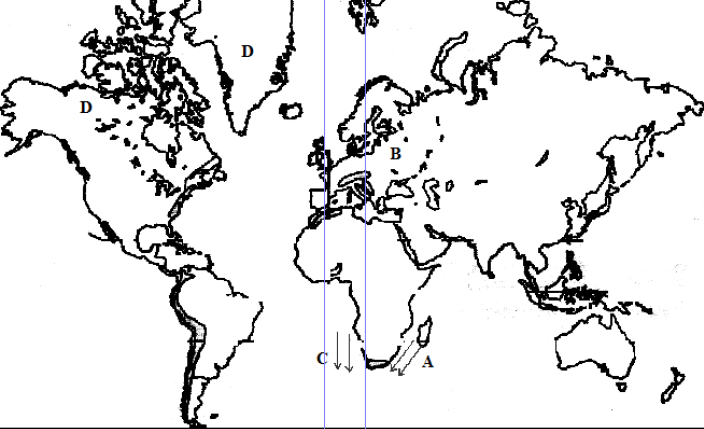
- Study the world map below and answer the questions that follow.
(a) (i) Name the climatic region marked B and D.
(ii)...(Solved)
Study the world map below and answer the questions that follow.

(a) (i) Name the climatic region marked B and D.
(ii) Name the ocean currents marked C and A.
(b) Describe the characteristics of the vegetation marked T.
(c) Explain how the vegetation in the area marked B adapt itself to the climatic conditions.
Date posted: May 29, 2019. Answers (1)
- Name two main seasons caused by the revolution of the earth.(Solved)
Name two main seasons caused by the revolution of the earth.
Date posted: May 29, 2019. Answers (1)
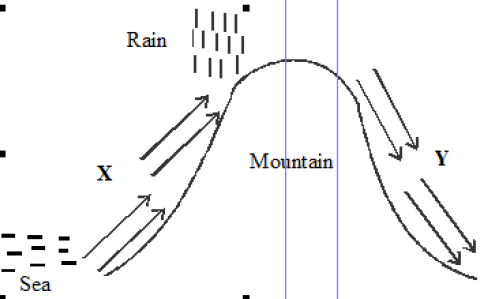
- The diagram below shows relief rainfall.
(i) Name the areas marked X and Y.
(ii) State three characteristics of the region marked Y.(Solved)
The diagram below shows relief rainfall.

(i) Name the areas marked X and Y.
(ii) State three characteristics of the region marked Y.
Date posted: May 29, 2019. Answers (1)
- Name three countries where the Trans-African railway line is not completed.(Solved)
Name three countries where the Trans-African railway line is not completed.
Date posted: May 29, 2019. Answers (1)
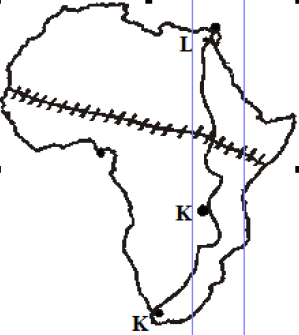
- The map below shows the proposed Trans-African railway and the Great North road.
Name the towns marked J, K and L on Great North road.(Solved)
The map below shows the proposed Trans-African railway and the Great North road.

Name the towns marked J, K and L on Great North road.
Date posted: May 29, 2019. Answers (1)
- The data below represents sugarcane production in five major factories in Kenya.
Use it to answer questions below.
Factory Production in...(Solved)
The data below represents sugarcane production in five major factories in Kenya.
Use it to answer questions below.
Factory Production in “000” tonnes
Sony 50
Nzoia 100
Chemelil 200
Muhoroni 250
Mumias 400
(i) Using the data above, draw a divided rectangle measuring 15cm in length.
(ii) Give the difference in tonnage produced by Muhoroni and Nzoia companies.
(iii) State two advantages of representing data using divided rectangles.
Date posted: May 29, 2019. Answers (1)
- State three evidences of soil creep in a given area.(Solved)
State three evidences of soil creep in a given area.
Date posted: May 29, 2019. Answers (1)
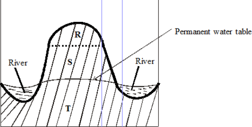
- The diagram below shows zones of underground water. Use it to answer the question.
Name the zones marked R, S and T.(Solved)
The diagram below shows zones of underground water. Use it to answer the question.

Name the zones marked R, S and T.
Date posted: May 28, 2019. Answers (1)