• Cool temperate continental climate/Siberian type.
• Cool temperate eastern margin- Laurentian type.
• West coast of Canada.
• Scandinavian region
Kavungya answered the question on June 7, 2019 at 12:27
- How do the following factors influence distribution of vegetation in Kenya.
(i) Variation in rainfall
(ii) Variation of temperature
(iii) Variation of altitude/relief.
(iv) Aspect
(v) Soil
(vi) Human activities(Solved)
How do the following factors influence distribution of vegetation in Kenya.
(i) Variation in rainfall
(ii) Variation of temperature
(iii) Variation of altitude/relief.
(iv) Aspect
(v) Soil
(vi) Human activities
Date posted: June 7, 2019. Answers (1)
- Explain three measures that the Kenyan government has taken to reduce the decline of natural vegetation cover.(Solved)
Explain three measures that the Kenyan government has taken to reduce the decline of natural vegetation cover.
Date posted: June 7, 2019. Answers (1)
- Name the temperate grasslands found in the following countries:
• Canada
• Russia
• Australia(Solved)
Name the temperate grasslands found in the following countries:
• Canada
• Russia
• Australia
Date posted: June 7, 2019. Answers (1)
- What is isothermal layer?(Solved)
What is isothermal layer?
Date posted: June 7, 2019. Answers (1)
- How does clearance of vegetation cause climate change?(Solved)
How does clearance of vegetation cause climate change?
Date posted: June 7, 2019. Answers (1)
- How does the following factors influence climate?
(i) Wind/air masses.
(ii) Latitude.(Solved)
How does the following factors influence climate?
(i) Wind/air masses.
(ii) Latitude.
Date posted: June 7, 2019. Answers (1)
- Explain how the following factors influence climate
(i) Altitude
(ii) Distance from the sea(Solved)
Explain how the following factors influence climate
(i) Altitude
(ii) Distance from the sea
Date posted: June 7, 2019. Answers (1)
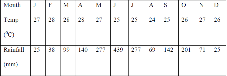
- The table below represents rainfall and temperature figures for a town in Africa. Use it to answer the questions that follow
(a) Calculate the annual range...(Solved)
The table below represents rainfall and temperature figures for a town in Africa. Use it to answer the questions that follow

(a) Calculate the annual range of temperature for the town
(b) Calculate the total annual rainfall for the town.
(c) State two characteristics of the climate experienced in the town.
Date posted: June 7, 2019. Answers (1)
- Distinguish between seismograph and seismogram.(Solved)
Distinguish between seismograph and seismogram.
Date posted: June 7, 2019. Answers (1)
- Give two effects of earthquakes in built up areas.(Solved)
Give two effects of earthquakes in built up areas.
Date posted: June 7, 2019. Answers (1)
- Give two of escarpments in East Africa.(Solved)
Give two of escarpments in East Africa.
Date posted: June 7, 2019. Answers (1)
- Name two examples of Horst Mountains in East Africa.(Solved)
Name two examples of Horst Mountains in East Africa.
Date posted: June 7, 2019. Answers (1)
- Explain formation of Fold Mountains by contraction theory.(Solved)
Explain formation of Fold Mountains by contraction theory.
Date posted: June 7, 2019. Answers (1)
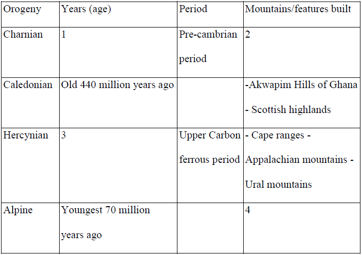
- Fill in the table provided details on age, period and features formed in each named orogenies.(Solved)
Fill in the table provided details on age, period and features formed in each named orogenies.

Date posted: June 7, 2019. Answers (1)
- Differentiate between foreland and back land.(Solved)
Differentiate between foreland and back land.
Date posted: June 7, 2019. Answers (1)
- Differentiate between limb and axis in relation to folding.(Solved)
Differentiate between limb and axis in relation to folding.
Date posted: June 7, 2019. Answers (1)
- Explain the meaning of compressional boundaries.(Solved)
Explain the meaning of compressional boundaries.
Date posted: June 7, 2019. Answers (1)
- State two advantages of studying landforms through field work.(Solved)
State two advantages of studying landforms through field work.
Date posted: June 7, 2019. Answers (1)
- How would students in your school prepare themselves for study of landforms in your district?(Solved)
How would students in your school prepare themselves for study of landforms in your district?
Date posted: June 7, 2019. Answers (1)
- Name one fold mountain in;
(i) Asia
(ii) North America
(iii) South America(Solved)
Name one fold mountain in;
(i) Asia
(ii) North America
(iii) South America
Date posted: June 7, 2019. Answers (1)