i) Why it is difficult to carry out field study of glaciated feature.
- Climbing the mountain is difficult due to rugged terrain.
- Features are found far from the schools/settlements
- Time may be inadequate
- Poor weather conditions i.e. rainfall and low temperatures
- Thick forest and dangerous animals which makes it difficult to
access such areas.
- It is difficult to conduct a previsit
- Avalanches
ii) How students would use the photograph of Mt. Kenya to identify
the glaciated features.
- By dividing it into parts
- By observing and identifying the features in each part of the photograph
- By recording the features observed
- By drawing sketches of the features observed
- By labeling the features observed.
Kavungya answered the question on June 8, 2019 at 06:39
- Explain the significance of upland glaciated features to human activities.(Solved)
Explain the significance of upland glaciated features to human activities.
Date posted: June 8, 2019. Answers (1)
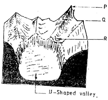
- The diagram below shows a glaciated upland area
(a) Name the feature marked P, Q, and R
(b) How is a U- shaped valley formed?(Solved)
The diagram below shows a glaciated upland area

(a) Name the feature marked P, Q, and R
(b) How is a U- shaped valley formed?
Date posted: June 8, 2019. Answers (1)
- Explain the significance of limestone regions.(Solved)
Explain the significance of limestone regions.
Date posted: June 8, 2019. Answers (1)
- Distinguish between the following.
(i) Effluent streams and influent streams.
(ii) Artesian basins and artesan well.(Solved)
Distinguish between the following.
(i) Effluent streams and influent streams.
(ii) Artesian basins and artesan well.
Date posted: June 8, 2019. Answers (1)
- Explain factors influencing formation of springs.(Solved)
Explain factors influencing formation of springs.
Date posted: June 8, 2019. Answers (1)
- Students carried out field study on desert landforms.
(i) State two type of information they collected through observation.
(ii) Which measures would they have recommended to control...(Solved)
Students carried out field study on desert landforms.
(i) State two type of information they collected through observation.
(ii) Which measures would they have recommended to control desertification?
Date posted: June 8, 2019. Answers (1)
- Explain the formation of the following features:
(a) Bajadas.
(b) Pediments.(Solved)
Explain the formation of the following features:
(a) Bajadas.
(b) Pediments.
Date posted: June 8, 2019. Answers (1)
- Differentiate between suspension and saltation.(Solved)
Differentiate between suspension and saltation.
Date posted: June 8, 2019. Answers (1)
- Distinguish between shingle beaches and sand beaches.(Solved)
Distinguish between shingle beaches and sand beaches.
Date posted: June 8, 2019. Answers (1)
- Describe formation of coral coast.(Solved)
Describe formation of coral coast.
Date posted: June 8, 2019. Answers (1)
- What are destructive waves?(Solved)
What are destructive waves?
Date posted: June 8, 2019. Answers (1)
- Define term coastline(Solved)
Define term coastline
Date posted: June 8, 2019. Answers (1)
- You are planning to carry out a field study on the depositional features along the coast of Kenya
(i) State five objectives you would formulate for...(Solved)
You are planning to carry out a field study on the depositional features along the coast of Kenya
(i) State five objectives you would formulate for your study
(ii) Give five methods you would use to record the information
collected
Date posted: June 8, 2019. Answers (1)
- State the differences between the lakes on the eastern and western areas of East African Rift Valley.(Solved)
State the differences between the lakes on the eastern and western areas of East African Rift Valley.
Date posted: June 7, 2019. Answers (1)
- Explain how each of the following lakes were formed :
(a) Victoria
(b) Tanganyika
(c) Chala
(d) Sare
(e) Kivu(Solved)
Explain how each of the following lakes were formed :
(a) Victoria
(b) Tanganyika
(c) Chala
(d) Sare
(e) Kivu
Date posted: June 7, 2019. Answers (1)
- With examples from Africa, explain the differences between the following river features:
(a) Inland delta and alluvial fan.
(b) Estuarine delta and an estuary.
(c) Bluff and river...(Solved)
With examples from Africa, explain the differences between the following river features:
(a) Inland delta and alluvial fan.
(b) Estuarine delta and an estuary.
(c) Bluff and river cliff.
(d) Levees and river bank.
(e) River valley and river channel.
(f) Paired terrace and unpaired terrace.
(g) Drainage pattern and drainage system,
(h) Misfit river and deferred river,
(i) Antecedent drainage and superimposed drainage.
Date posted: June 7, 2019. Answers (1)
- Explain the following:
(a) River basin
(b) Watershed
(c) Catchment area
(d) River regime(Solved)
Explain the following:
(a) River basin
(b) Watershed
(c) Catchment area
(d) River regime
Date posted: June 7, 2019. Answers (1)
- In what ways can we sustain the process of the hydrological cycle?(Solved)
In what ways can we sustain the process of the hydrological cycle?
Date posted: June 7, 2019. Answers (1)
- What is cryosphere?(Solved)
What is cryosphere?
Date posted: June 7, 2019. Answers (1)
- Explain factors that influence percolation of water.(Solved)
Explain factors that influence percolation of water.
Date posted: June 7, 2019. Answers (1)