(i)
A – Pyramidal peak
B – Arete
C – Waterfall
D – Glacial trough/glacial valley
(ii)
A –Pyramidal peak
(a) Ice settles on several shallow hollows around the mountain side
(b) Freeze-thaw action deepens the hollows.
(c) Nivation, plucking and abrasion attack the sides and floor of the depression leading to the formation of many cirques.
(d) The back walls of the cirques recede as a result of plucking leading to the formation of
arêtes.
(e) The arêtes converge at the mountain top forming a steep-side pyramidal peak/horn
surrounded by corries.
D – Glacial trough
(a) As the glacier moves down the valley it is feed by several tributary glaciers.
(b) Its erosive power increases causing it to deepen, straighten and widen its valley.
(c) As a result a wide flat-bottomed valley with a u-shaped cross profile known as a glacier
trough is formed.
maurice.mutuku answered the question on August 7, 2019 at 06:22
- Explain three importance of underground water.(Solved)
Explain three importance of underground water.
Date posted: August 7, 2019. Answers (1)
- Study the table below and answer the question.(Solved)
Study the table below and answer the question.

(i) Calculate the mean annual rainfall.
(ii) What is the annual range of temperature?
Date posted: August 7, 2019. Answers (1)
- Name two ice capped mountains in Africa.(Solved)
Name two ice capped mountains in Africa.
Date posted: August 7, 2019. Answers (1)
- You are planning to carry out field study on the relationship betweenclimate and vegetation.(Solved)
You are planning to carry out field study on the relationship between climate and vegetation.
(i) State three objective of your filed study.
(ii) Give three measures you would recommend to combat desertification.
Date posted: August 7, 2019. Answers (1)
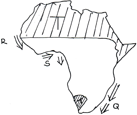
- Use the map of Africa below to answer the questions that follow.(Solved)
Use the map of Africa below to answer the questions that follow.

(i) Name the ocean currents marked R and S.
(ii) Explain how the ocean current marked Q influence the climate of the adjacent land.
(iii) Describe the characteristics of the climatic region marked T.
Date posted: August 7, 2019. Answers (1)
- Name the type of delta found on River:
(i) Tana
(ii) Omo(Solved)
Name the type of delta found on River:
(i) Tana
(ii) Omo
Date posted: August 6, 2019. Answers (1)
- With the aid of a well labelled diagram, illustrate the hydrological cycle.(Solved)
With the aid of a well labelled diagram, illustrate the hydrological cycle.
Date posted: August 6, 2019. Answers (1)
- Your class undertook a field study on lakes formed through faulting.
(a) Give two characteristic features of lakes you may have identified.
(b) State three uses...(Solved)
Your class undertook a field study on lakes formed through faulting.
(a) Give two characteristic features of lakes you may have identified.
(b) State three uses of the lakes that you may have found.
(c) Give two benefits of studying lakes through field study.
Date posted: August 6, 2019. Answers (1)
- With the aid of clearly labelled diagrams, describe the formation of the Rift Valley by compressional theory.(Solved)
With the aid of clearly labelled diagrams, describe the formation of the Rift Valley by compressional theory.
Date posted: August 6, 2019. Answers (1)
- What name is given to the shape of the earth?(Solved)
What name is given to the shape of the earth?
Date posted: August 6, 2019. Answers (1)
- Form four students wanted to carry out a field study on soil. Give reasonswhy they should seek permission from authorities(Solved)
Form four students wanted to carry out a field study on soil. Give reasons why they should seek permission from authorities.
Date posted: August 6, 2019. Answers (1)
- Explain ways of conserving soil(Solved)
Explain ways of conserving soil
Date posted: August 6, 2019. Answers (1)
- Form four students carried a field study on coastal land forms.
State methods they might have used to record their data(Solved)
Form four students carried a field study on coastal land forms.
State methods they might have used to record their data
Date posted: August 6, 2019. Answers (1)
- Describe two ways in which water moves in ocean and seas(Solved)
Describe two ways in which water moves in ocean and seas
Date posted: August 6, 2019. Answers (1)
- Students of Moi University Mt. Kenya campus wanted to carry a field study at Mt. Kenya forest, state four preparations they should make before in...(Solved)
Students of Moi University Mt. Kenya campus wanted to carry a field study at Mt. Kenya forest, state preparations they should make before in actual field study.
Date posted: August 6, 2019. Answers (1)
- Highlight features formed in the upper course of the river(Solved)
Highlight features formed in the upper course of the river
Date posted: August 6, 2019. Answers (1)
- What is a river regime?(Solved)
What is a river regime?
Date posted: August 6, 2019. Answers (1)
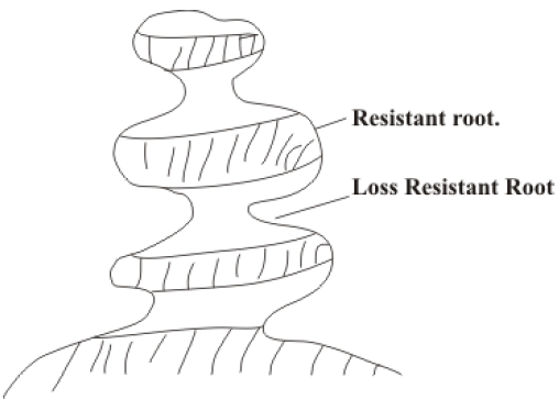
- The diagram below shows rock pedestal.(Solved)
The diagram below shows rock pedestal.

Name the process through which the wind erodes the above feature
Date posted: August 6, 2019. Answers (1)
- Name two features found in each of the following parts of a Karst scenery.(a) Surface(b) Underground(Solved)
Name two features found in each of the following parts of a Karst scenery.
(a) Surface
(b) Underground
Date posted: August 6, 2019. Answers (1)
- What is a Karst scenery?(Solved)
What is a Karst scenery?
Date posted: August 6, 2019. Answers (1)