(i) Slope of the land
(ii) Difference in rock resistance or hardness
(iii) The rock structure a long a river profile
maurice.mutuku answered the question on August 7, 2019 at 07:33
- The local time of town A 400E is 12 noon.
What will be the local time of B 300E?(Solved)
The local time of town A 400E is 12 noon.
What will be the local time of B 300E?
Date posted: August 7, 2019. Answers (1)
- Suppose you were to carry out a field study of a glaciated highland:
(i) State two disadvantages of using observation as a method of data collection.
...(Solved)
Suppose you were to carry out a field study of a glaciated highland:
(i) State two disadvantages of using observation as a method of data collection.
(ii) State two problems you are likely to encounter.
(iii) Suggest two economic activities you would recommend to the Government in this area.
Date posted: August 7, 2019. Answers (1)
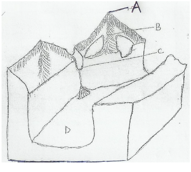
- Study the diagram below which shows a glaciated highland and answer questions that follow(Solved)
Study the diagram below which shows a glaciated highland and answer questions (i) and (ii)

i) Name the features marked A, B, C and D.
ii) Describe how features A and D were formed.
Date posted: August 7, 2019. Answers (1)
- Explain three importance of underground water.(Solved)
Explain three importance of underground water.
Date posted: August 7, 2019. Answers (1)
- Study the table below and answer the question.(Solved)
Study the table below and answer the question.

(i) Calculate the mean annual rainfall.
(ii) What is the annual range of temperature?
Date posted: August 7, 2019. Answers (1)
- Name two ice capped mountains in Africa.(Solved)
Name two ice capped mountains in Africa.
Date posted: August 7, 2019. Answers (1)
- You are planning to carry out field study on the relationship betweenclimate and vegetation.(Solved)
You are planning to carry out field study on the relationship between climate and vegetation.
(i) State three objective of your filed study.
(ii) Give three measures you would recommend to combat desertification.
Date posted: August 7, 2019. Answers (1)
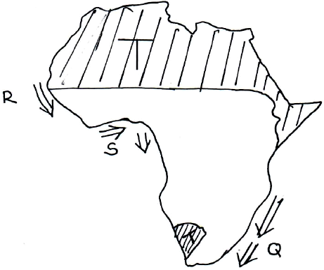
- Use the map of Africa below to answer the questions that follow.(Solved)
Use the map of Africa below to answer the questions that follow.

(i) Name the ocean currents marked R and S.
(ii) Explain how the ocean current marked Q influence the climate of the adjacent land.
(iii) Describe the characteristics of the climatic region marked T.
Date posted: August 7, 2019. Answers (1)
- Name the type of delta found on River:
(i) Tana
(ii) Omo(Solved)
Name the type of delta found on River:
(i) Tana
(ii) Omo
Date posted: August 6, 2019. Answers (1)
- With the aid of a well labelled diagram, illustrate the hydrological cycle.(Solved)
With the aid of a well labelled diagram, illustrate the hydrological cycle.
Date posted: August 6, 2019. Answers (1)
- Your class undertook a field study on lakes formed through faulting.
(a) Give two characteristic features of lakes you may have identified.
(b) State three uses...(Solved)
Your class undertook a field study on lakes formed through faulting.
(a) Give two characteristic features of lakes you may have identified.
(b) State three uses of the lakes that you may have found.
(c) Give two benefits of studying lakes through field study.
Date posted: August 6, 2019. Answers (1)
- With the aid of clearly labelled diagrams, describe the formation of the Rift Valley by compressional theory.(Solved)
With the aid of clearly labelled diagrams, describe the formation of the Rift Valley by compressional theory.
Date posted: August 6, 2019. Answers (1)
- What name is given to the shape of the earth?(Solved)
What name is given to the shape of the earth?
Date posted: August 6, 2019. Answers (1)
- Form four students wanted to carry out a field study on soil. Give reasonswhy they should seek permission from authorities(Solved)
Form four students wanted to carry out a field study on soil. Give reasons why they should seek permission from authorities.
Date posted: August 6, 2019. Answers (1)
- Explain ways of conserving soil(Solved)
Explain ways of conserving soil
Date posted: August 6, 2019. Answers (1)
- Form four students carried a field study on coastal land forms.
State methods they might have used to record their data(Solved)
Form four students carried a field study on coastal land forms.
State methods they might have used to record their data
Date posted: August 6, 2019. Answers (1)
- Describe two ways in which water moves in ocean and seas(Solved)
Describe two ways in which water moves in ocean and seas
Date posted: August 6, 2019. Answers (1)
- Students of Moi University Mt. Kenya campus wanted to carry a field study at Mt. Kenya forest, state four preparations they should make before in...(Solved)
Students of Moi University Mt. Kenya campus wanted to carry a field study at Mt. Kenya forest, state preparations they should make before in actual field study.
Date posted: August 6, 2019. Answers (1)
- Highlight features formed in the upper course of the river(Solved)
Highlight features formed in the upper course of the river
Date posted: August 6, 2019. Answers (1)
- What is a river regime?(Solved)
What is a river regime?
Date posted: August 6, 2019. Answers (1)