-Cold Ocean currents blowing along coastal regions bring cold conditions
- Cold conditions lead to the formation of fog and mist
-Ground and air along such areas is not heated hence no Turbulance
- Winds also carry no moisture hence they are dry.
- Winds drop their moisture over, the sea- reaching the land as dry winds
- Winds pick moisture on land making the areas more dry.
maurice.mutuku answered the question on August 9, 2019 at 13:10
-
What is temperature inversion?
(Solved)
What is temperature inversion?
Date posted:
August 9, 2019
.
Answers (1)
-
The diagram below shows a folded region, name the feature marked K.
(Solved)
The diagram below shows a folded region, name the feature marked K.

Date posted:
August 9, 2019
.
Answers (1)
-
Name the instrument that measures seismic waves.
(Solved)
Name the instrument that measures seismic waves.
Date posted:
August 9, 2019
.
Answers (1)
-
State two characteristics of S waves generated by an earthquakes
(Solved)
State two characteristics of S waves generated by an earthquakes
Date posted:
August 9, 2019
.
Answers (1)
-
Apart from secondary waves,name two other types of waves generated by an earthquake
(Solved)
Apart from secondary waves, name two other types of waves generated by an earthquake
Date posted:
August 9, 2019
.
Answers (1)
-
Suppose students were to carry out a field study on glaciations on Mt. Kenya:
(Solved)
Suppose students were to carry out a field study on glaciations on Mt. Kenya:
(i) Give two reasons why they would need a route map.
(ii) Name two types of moraines they are likely to study.
(iii) State two problems they are likely to experience during the field study.
Date posted:
August 9, 2019
.
Answers (1)
-
Name two examples of Lakes in Kenya formed by tectonic movement.
(Solved)
Name two examples of Lakes in Kenya formed by tectonic movement.
Date posted:
August 9, 2019
.
Answers (1)
-
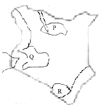
The map below shows the climatic regions of Kenya.
(Solved)
The map below shows the climatic regions of Kenya.

Name the parts marked Q and R.
Give four development activities that the Kenyan government could initiate
sustainably in the region marked P.
Date posted:
August 9, 2019
.
Answers (1)
-
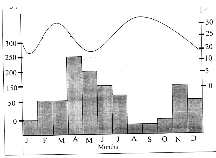
The graph below shows climatic characteristics of a station in Kenya. Use to answer the following questions.
(Solved)
The graph below shows climatic characteristics of a station in Kenya. Use to answer the following questions.

(i) Calculate the annual range of temperatures.
(ii) Calculate the annual total amount of rainfall received at the station.
Date posted:
August 9, 2019
.
Answers (1)
-
With the aid of a well labeled diagram, describe how a recumbent fold is formed.
(Solved)
With the aid of a well labeled diagram, describe how a recumbent fold is formed.
Date posted:
August 9, 2019
.
Answers (1)
-
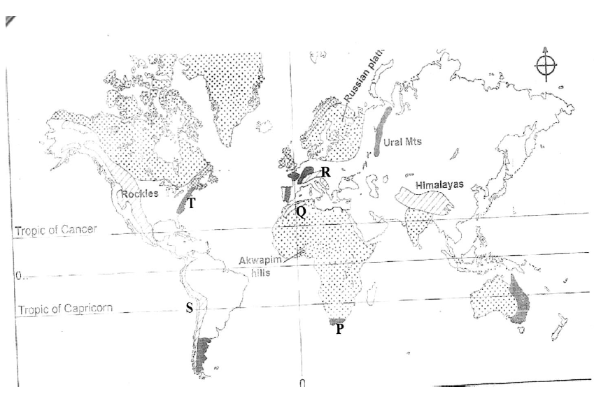
The following map shows the location of fold mountain ranges of the world.
(Solved)
The following map shows the location of fold mountain ranges of the world.

Name the features marked P, Q, R, S and T.
Date posted:
August 9, 2019
.
Answers (1)
-
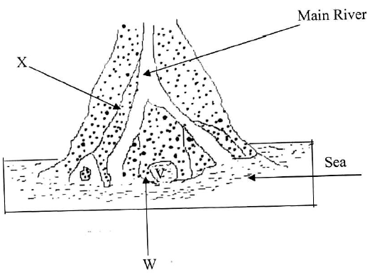
The diagram below shows a delta.
(Solved)
The diagram below shows a delta.

Name the features marked V, W and X.
Date posted:
August 9, 2019
.
Answers (1)
-
Define the term “Estuary.”
(Solved)
Define the term “Estuary.”
Date posted:
August 9, 2019
.
Answers (1)
-
Name two escarpments found within the Gregory rift system.
(Solved)
Name two escarpments found within the Gregory rift system.
Date posted:
August 9, 2019
.
Answers (1)
-
You have been asked to carry out a field study in causes of soil erosion in a region near your school.
(Solved)
You have been asked to carry out a field study in causes of soil erosion in a region near your school.
(i) Mention two methods you would use to collect data during the study.
(ii) Mention two activities you would undertake during the field study.
(iii) Mention one follow up activity you would carry out after the field study.
Date posted:
August 9, 2019
.
Answers (1)
-
Explain how the following factors cause loss of soil fertility:
(Solved)
Explain how the following factors cause loss of soil fertility:
(i) Irrigation in arid and semi arid regions.
(ii) Destruction of soil structure.
Date posted:
August 9, 2019
.
Answers (1)
-
Explain two negative effects of glaciations on the physical environment.
(Solved)
Explain two negative effects of glaciations on the physical environment.
Date posted:
August 9, 2019
.
Answers (1)
-
Describe how Roche Mountonée is formed
(Solved)
Describe how Roche Mountonée is formed
Date posted:
August 9, 2019
.
Answers (1)
-
Name three methods used to estimate the age of rocks.
(Solved)
Name three methods used to estimate the age of rocks.
Date posted:
August 9, 2019
.
Answers (1)
-
State two characteristics of intrusive igneous rocks.
(Solved)
State two characteristics of intrusive igneous rocks.
Date posted:
August 9, 2019
.
Answers (1)