(a) Warm Fronts
When a mass of warm (usually moist) air encounters a mass of cold air, we have a warm front. The warm air, which is lighter and less dense, pushes up in a wedge like formation a top the mass of cold air (figure 2). However the slope formed by the upward-moving mass of warm air with the horizontal surface is on the order of about 1 to 300, i.e. the upward rise would be about 1 km for every 300 km of horizontal surface.
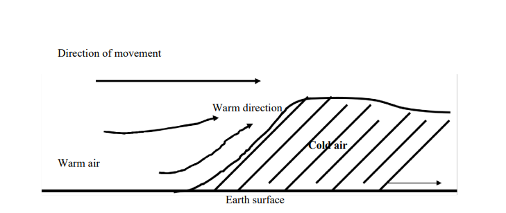
A warm front creates a wide band of weather because of the lifting of the warm air. There is often considerable cloud cover and precipitation along the frontal surface. The air mass is usually unstable and convection produces rapid uplift followed by precipitation.
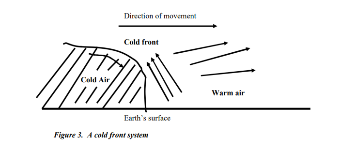
(a) Cold Fronts
When winds from the north bring cold air toward a band of warm air, a cold front results. The heavier, denser cold air pushes in under the warm air and rapidly forces it upward at a sharp angle (figure 3). That is why a cold front forms a much steeper wedge than a warm front. In cold fronts, the ratio between the ascent of air and the horizontal surface is on the order of about 1 to 50 (i.e. 1 km vertical rise for every 50 km of horizontal surface).
Cold fronts generally produce much narrower bands of weather than warm fronts, and exhibit the results of convection processes more markedly. The frontal line of a cold front slopes sharply backward, rather than in the same direction the front is moving. The warm air, initially at the surface of the Earth is replaced by the oncoming cold air mass. In winter, cold fronts generally approach more rapidly than they do in summer. The winds are stronger.
In a cold front system, the predominant type of cloud is the cumulus, and frequent thunderstorms occur (which is not a typical occurrence in warm fronts). The weather patterns occur in narrow bands. The degree of activity depends on whether the warm air is being pushed up from the surface quickly or slowly. If the warm air rises slowly, the rate of cooling is of course slower and the disturbance of the cold front is less violent.
(c) Stationary Fronts
When a frontal system stops moving forward, a stationary front occurs. Stationary fronts may result from the stalling of either a cold or warm front, and may remain stationary for several days. When a stationary front starts to move again, it may be either a warm front or a cold one. The discontinuity of temperatures often weakens and the front simply dissipates. In a stationary front the weather conditions are fair and stable.
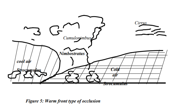
(d) Occluded Fronts
When a cold frontal system overtakes a warm frontal system, the two fronts trap air between them that is much warmer than the surrounding masses of air. Occluded fronts result.
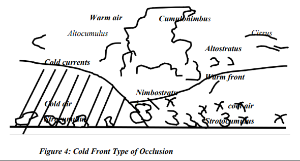
Occlusion takes place when a mass of warm air is pushed upward and removed from the ground by two dense masses of cold air. These air masses meet and push the warmer mass of air off the ground surface between them. In a cold-front occlusion (figure 4) a warm front is pushed off the ground by the advancing cold heavy air. In a warm front occlusion, a cold front is pushed off the ground because the air in the dancing warm front is colder at the leading edge than the air in the cold front with which it is colluding.
francis1897 answered the question on
October 5, 2022 at 09:08