I) X- Coastal plain / lowland , Y- Kenya highland/ Central highlands
Z- The lake basin / lake plateau
ii) S- fishing , T – Mining
iii) The underlying molten rock escaped through a vent to the surface (a v0lcanic eruption occurred ) There were violent eruption , which ejected acidic lava which later cooled and solidified . The lava piled in layers around the vent .The lava did not flow very far from the vent since it was acidic/ viscous . Over the years , eruption ceased and the volcano became extinct. Erosion set is exposing the plug and producing the jugged peak of the mountain . This led to formation of steep sided volcano known as mount Kenya
johnmulu answered the question on October 3, 2017 at 11:46
- The map below shows the physical region of Kenya . Use it to answer the Question that follows (Solved)
The map below shows the physical region of Kenya . Use it to answer the Question that follows
i)Name the region marked X Y and Z
ii) Give the major economic importance of each of the lakes marked S and T
iii) Describe how Mt Kenya was formed
Date posted: October 3, 2017. Answers (1)
- The diagram below represent feature produced by faulting . use it to answer Question(Solved)
The diagram below represent feature produced by faulting . use it to answer Question
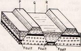
a) Name the feature marked p , Q and R
b)Differentiate between a normal fault and reverse fault
Date posted: October 3, 2017. Answers (1)
- The map below shows the location of some mountain ranges.(Solved)
The map below shows the location of some mountain ranges.
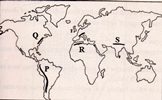
a) Name the ranges marked P ,Q , R and S
B. i) Apart from Fold mountains , name three other features resulting from folding
II) With the aid of labelled diagrams , describe how fold mountain are formed
C) Explain the significance of Fold mountains to human activities
Date posted: October 3, 2017. Answers (1)
- The map below shows the location of some mountain ranges.(Solved)
The map below shows the location of some mountain ranges.
a) Name the ranges marked P ,Q , R and S
B. i) Apart from Fold mountains , name three other features resulting from folding
II) With the aid of labelled diagrams , describe how fold mountain are formed
C) Explain the significance of Fold mountains to human activities
Date posted: October 3, 2017. Answers (1)
- The diagram below shows some types of folds. Use it to answer question
(Solved)
The diagram below shows some types of folds. Use it to answer question
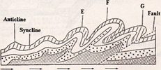
a) Name the types of fold marked E, F and G
b) In which counties are the following fold mountain found?
(i) Andes
(ii) Cape Range
(iii) Alps
Date posted: October 3, 2017. Answers (1)
- The diagram below shows some features formed as a result of faulting
(Solved)
The diagram below shows some features formed as a result of faulting
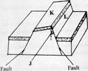
Identify: (I) the angle marked j
(II) the feature marked k and l.
Date posted: October 3, 2017. Answers (1)
- The diagram below represent the structure of the atmosphere . use it to answer question(Solved)
The diagram below represent the structure of the atmosphere . use it to answer question
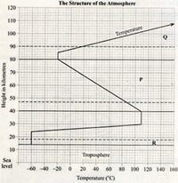
(a) Name : (I) the parts marked p and Q
(ii) The layer of discontinuity marked R
(b) state two characteristics of the weather condition in the atmosphere.
Date posted: October 3, 2017. Answers (1)
- State characteristics of equatorial rain forest.(Solved)
State characteristics of equatorial rain forest.
Date posted: October 2, 2017. Answers (1)
- State the characteristics of minerals(Solved)
State the characteristics of minerals.
Date posted: October 2, 2017. Answers (1)
- State advantages of using cumulative bar graphs.(Solved)
State advantages of using cumulative bar graphs.
Date posted: October 2, 2017. Answers (1)
- State techniques of collecting data (Solved)
State techniques of collecting data
Date posted: October 2, 2017. Answers (1)
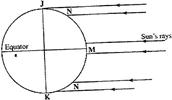
- The diagram below shows the angles of the sun's rays at different latitudes when the sun is at the equator. Use it to answer question...(Solved)
The diagram below shows the angles of the sun's rays at different latitudes when the sun is at the equator. Use it to answer question (a) and (b).
Date posted: September 30, 2017. Answers (1)
- Use the diagram below to answer the question that follows. (Solved)
Use the diagram below to answer the question that follows.
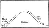
Outline the process through which the moist winds shown go through to eventually become dry winds
Date posted: September 30, 2017. Answers (1)
- State four efforts that have been made to improve transport in Africa.(Solved)
State four efforts that have been made to improve transport in Africa.
Date posted: September 30, 2017. Answers (1)
- Give two reasons why it is difficult to transport goods from Mombasa to Lagos by road.(Solved)
Give two reasons why it is difficult to transport goods from Mombasa to Lagos by road.
Date posted: September 30, 2017. Answers (1)
- Explain four advantages of rail transport over road transport.(Solved)
Explain four advantages of rail transport over road transport.
Date posted: September 30, 2017. Answers (1)
- State two problems facing communication in Kenya.(Solved)
State two problems facing communication in Kenya.
Date posted: September 30, 2017. Answers (1)
- Give three ways in which cell phones contribute to Kenya’s economic development.(Solved)
Give three ways in which cell phones contribute to Kenya’s economic development.
Date posted: September 30, 2017. Answers (1)
- Name three main modes of transport in Kenya.(Solved)
Name three main modes of transport in Kenya.
Date posted: September 30, 2017. Answers (1)
- Give three measures used to conserve forests in Kenya.(Solved)
Give three measures used to conserve forests in Kenya.
Date posted: September 30, 2017. Answers (1)