- The site was strategic calling point for early traders to and from East Africa.
- The island provided a good defensive site against external aggression.
- The coral limestone found in the area was used for building.
- The fland land was ideal for construction of buildings.
- The two rivers Mwachi and Kombeni provided fresh water for the settlers.
- The deep water at the kilindini Creek provided a well sheltered natural harbour.
- Mombasa has a large and rich hinterland which covers Kenya Rwanda and Southern Sudan.
gideon1 answered the question on October 4, 2017 at 04:58
- State three main functions of rural settlements.(Solved)
State three main functions of rural settlements.
Date posted: October 4, 2017. Answers (1)
- Name two types of indigenous hard wood trees found in Kenyan forests.(Solved)
Name two types of indigenous hard wood trees found in Kenyan forests.
Date posted: October 4, 2017. Answers (1)
- Identify three factors that favored the location of cement processing plant Athi River near
Nairobi(Solved)
Identify three factors that favored the location of cement processing plant Athi River near
Nairobi
Date posted: October 4, 2017. Answers (1)
- State four factors that influence development of industries in Kenya(Solved)
State four factors that influence development of industries in Kenya
Date posted: October 4, 2017. Answers (1)
- State three ways in which marine fisheries in Kenya can be conserved(Solved)
State three ways in which marine fisheries in Kenya can be conserved
Date posted: October 4, 2017.
- The map below shows the physical region of Kenya . Use it to answer the Question that follows (Solved)
The map below shows the physical region of Kenya . Use it to answer the Question that follows
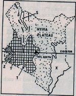
i)Name the region marked X Y and Z
ii) Give the major economic importance of each of the lakes marked S and T
iii) Describe how Mt Kenya was formed
Date posted: October 3, 2017. Answers (1)
- The map below shows the physical region of Kenya . Use it to answer the Question that follows (Solved)
The map below shows the physical region of Kenya . Use it to answer the Question that follows
i)Name the region marked X Y and Z
ii) Give the major economic importance of each of the lakes marked S and T
iii) Describe how Mt Kenya was formed
Date posted: October 3, 2017. Answers (1)
- The diagram below represent feature produced by faulting . use it to answer Question(Solved)
The diagram below represent feature produced by faulting . use it to answer Question
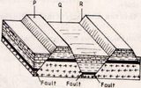
a) Name the feature marked p , Q and R
b)Differentiate between a normal fault and reverse fault
Date posted: October 3, 2017. Answers (1)
- The map below shows the location of some mountain ranges.(Solved)
The map below shows the location of some mountain ranges.
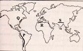
a) Name the ranges marked P ,Q , R and S
B. i) Apart from Fold mountains , name three other features resulting from folding
II) With the aid of labelled diagrams , describe how fold mountain are formed
C) Explain the significance of Fold mountains to human activities
Date posted: October 3, 2017. Answers (1)
- The map below shows the location of some mountain ranges.(Solved)
The map below shows the location of some mountain ranges.
a) Name the ranges marked P ,Q , R and S
B. i) Apart from Fold mountains , name three other features resulting from folding
II) With the aid of labelled diagrams , describe how fold mountain are formed
C) Explain the significance of Fold mountains to human activities
Date posted: October 3, 2017. Answers (1)
- The diagram below shows some types of folds. Use it to answer question
(Solved)
The diagram below shows some types of folds. Use it to answer question
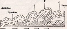
a) Name the types of fold marked E, F and G
b) In which counties are the following fold mountain found?
(i) Andes
(ii) Cape Range
(iii) Alps
Date posted: October 3, 2017. Answers (1)
- The diagram below shows some features formed as a result of faulting
(Solved)
The diagram below shows some features formed as a result of faulting
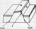
Identify: (I) the angle marked j
(II) the feature marked k and l.
Date posted: October 3, 2017. Answers (1)
- The diagram below represent the structure of the atmosphere . use it to answer question(Solved)
The diagram below represent the structure of the atmosphere . use it to answer question
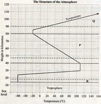
(a) Name : (I) the parts marked p and Q
(ii) The layer of discontinuity marked R
(b) state two characteristics of the weather condition in the atmosphere.
Date posted: October 3, 2017. Answers (1)
- State characteristics of equatorial rain forest.(Solved)
State characteristics of equatorial rain forest.
Date posted: October 2, 2017. Answers (1)
- State the characteristics of minerals(Solved)
State the characteristics of minerals.
Date posted: October 2, 2017. Answers (1)
- State advantages of using cumulative bar graphs.(Solved)
State advantages of using cumulative bar graphs.
Date posted: October 2, 2017. Answers (1)
- State techniques of collecting data (Solved)
State techniques of collecting data
Date posted: October 2, 2017. Answers (1)
- The diagram below shows the angles of the sun's rays at different latitudes when the sun is at the equator. Use it to answer question...(Solved)
The diagram below shows the angles of the sun's rays at different latitudes when the sun is at the equator. Use it to answer question (a) and (b).
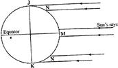
Date posted: September 30, 2017. Answers (1)
- Use the diagram below to answer the question that follows. (Solved)
Use the diagram below to answer the question that follows.
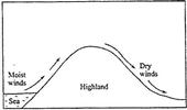
Outline the process through which the moist winds shown go through to eventually become dry winds
Date posted: September 30, 2017. Answers (1)
- State four efforts that have been made to improve transport in Africa.(Solved)
State four efforts that have been made to improve transport in Africa.
Date posted: September 30, 2017. Answers (1)